Missouri River: Difference between revisions
Jump to navigation
Jump to search

Pat Palmer (talk | contribs) mNo edit summary |
Pat Palmer (talk | contribs) mNo edit summary |
||
| Line 1: | Line 1: | ||
{{subpages}} | {{subpages}} | ||
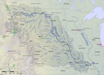
{{Image| | {{Image|Missouri River basin map.png|right|350px|The Missouri River system lies inland in the middle of the United States of America and forms the northeast state line for the state of [[Missouri]].}} | ||
The '''Missouri River''' is located in the north central [[United States of America|U.S.]], draining from [[Montana]] 2315 miles to the [[Mississippi River]] at [[St. Louis, Missouri|St. Louis]]. | The '''Missouri River''' is located in the north central [[United States of America|U.S.]], draining from [[Montana]] 2315 miles to the [[Mississippi River]] at [[St. Louis, Missouri|St. Louis]]. | ||
Revision as of 12:46, 4 July 2023

The Missouri River system lies inland in the middle of the United States of America and forms the northeast state line for the state of Missouri.
The Missouri River is located in the north central U.S., draining from Montana 2315 miles to the Mississippi River at St. Louis.