Khyber Pass: Difference between revisions
Pat Palmer (talk | contribs) mNo edit summary |
Pat Palmer (talk | contribs) (revising the intro to kit the main points) |
||
| Line 1: | Line 1: | ||
{{subpages}} | {{subpages}} | ||
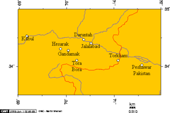
{{Image|Kabul, Peshawar, and some cities in Nangarhar, Afghanistan 6.png|right|350px| Kabul, Peshawar, and some cities in Nangarhar, Afghanistan.}} | {{Image|Kabul, Peshawar, and some cities in Nangarhar, Afghanistan 6.png|right|350px| Kabul, Peshawar, and some cities in Nangarhar, Afghanistan.}} | ||
The '''Khyber Pass''' is a mountain pass near the boundary between Afghanistan and Pakistan lying at 1,070 m (3,510 ft) above sea level. | The '''Khyber Pass''' is a mountain pass near the boundary between Afghanistan and Pakistan lying at 1,070 m (3,510 ft) above sea level. Its road runs through the [[Hindu Kush]] mountains. The pass is a vulnerable point militarily was traversed by [[Alexander the Great]] of [[Greece]] to invade India and use by the military forces of [[Genghis Khan]] of [[Mongolia]], Darius the Great of[[ Persia]], and many others. The pass also was always an important trade route between Central and South Asia and lay along the Silk Road, the ancient trade route linking China with the West. | ||
One of the few paved roads in Afghanistan travels through the pass, from the national capital, [[Kabul]], through [[Jalalabad]], the capital of [[Nangarhar Province]], and one of Afghanistan's largest cities, to the border with Pakistan, at [[Towr Kham]]. The road then continues to [[Peshawar]], Pakistan. | One of the few paved roads in Afghanistan travels through the pass, from the national capital, [[Kabul]], through [[Jalalabad]], the capital of [[Nangarhar Province]], and one of Afghanistan's largest cities, to the border with Pakistan, at [[Towr Kham]]. The road then continues to [[Peshawar]], Pakistan. | ||
Revision as of 14:22, 25 February 2024
The Khyber Pass is a mountain pass near the boundary between Afghanistan and Pakistan lying at 1,070 m (3,510 ft) above sea level. Its road runs through the Hindu Kush mountains. The pass is a vulnerable point militarily was traversed by Alexander the Great of Greece to invade India and use by the military forces of Genghis Khan of Mongolia, Darius the Great ofPersia, and many others. The pass also was always an important trade route between Central and South Asia and lay along the Silk Road, the ancient trade route linking China with the West.
One of the few paved roads in Afghanistan travels through the pass, from the national capital, Kabul, through Jalalabad, the capital of Nangarhar Province, and one of Afghanistan's largest cities, to the border with Pakistan, at Towr Kham. The road then continues to Peshawar, Pakistan.
