Iowa (U.S. state): Difference between revisions
Jump to navigation
Jump to search

imported>James F. Perry (add shaded relief map) |
Pat Palmer (talk | contribs) |
||
| (8 intermediate revisions by the same user not shown) | |||
| Line 1: | Line 1: | ||
{{subpages}} | {{subpages}} | ||
{{dambigbox|Iowa (U.S. state)|Iowa}} | |||
[[Image:North mid west.jpg|right|350px]] | [[Image:North mid west.jpg|right|350px]] | ||
'''Iowa''' is one of the states constituting the [[United States of America]]; it entered the Union as 29th state on December 28, 1846. Its area is 56,275 square miles (145,753 square kilometers). Its population was in 2008 estimated to be 3,002,555. | '''Iowa''' is one of the states constituting the [[United States of America]]; it entered the Union as 29th state on December 28, 1846. Its area is 56,275 square miles (145,753 square kilometers). Its population was in 2008 estimated to be 3,002,555. | ||
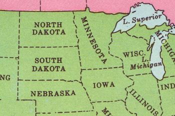
The [[Mississippi River]] forms its entire eastern border. The state is bordered on the north by [[Minnesota]], on the east by [[Wisconsin]] and [[Illinois]], on the south by [[Missouri]], and on the west by [[Nebraska]] and [[South Dakota]]. Its capital and largest city is [[Des Moines]]. | The [[Mississippi River]] forms its entire eastern border. The state is bordered on the north by [[Minnesota (U.S. state)|Minnesota]], on the east by [[Wisconsin (U.S. state)|Wisconsin]] and [[Illinois (U.S. state)]], on the south by [[Missouri (U.S. state)|Missouri]], and on the west by [[Nebraska (U.S. state)|Nebraska]] and [[South Dakota (U.S. state)|South Dakota]] . Its capital and largest city is [[Des Moines]]. | ||
The [[University of Iowa]], situated in [[Iowa city]] opened in 1855. [[Iowa State University]] of Science and Technology, in [[Ames (Iowa)|Ames]], started classes in 1869. | The [[University of Iowa]], situated in [[Iowa city]] opened in 1855. [[Iowa State University]] of Science and Technology, in [[Ames (Iowa)|Ames]], started classes in 1869. | ||
{{Image|Iowa.jpg|right|225px|USGS shaded relief map of Iowa | {{Image|Iowa.jpg|right|225px|USGS shaded relief map of Iowa | ||
a}} | a}} | ||
== | ==See also== | ||
[[United States of America/Catalogs/States and Territories|U.S. States and Territories]] | |||
Latest revision as of 13:07, 9 August 2023
This article is about Iowa (U.S. state). For other uses of the term Iowa, please see Iowa (disambiguation).

Iowa is one of the states constituting the United States of America; it entered the Union as 29th state on December 28, 1846. Its area is 56,275 square miles (145,753 square kilometers). Its population was in 2008 estimated to be 3,002,555.
The Mississippi River forms its entire eastern border. The state is bordered on the north by Minnesota, on the east by Wisconsin and Illinois (U.S. state), on the south by Missouri, and on the west by Nebraska and South Dakota . Its capital and largest city is Des Moines.
The University of Iowa, situated in Iowa city opened in 1855. Iowa State University of Science and Technology, in Ames, started classes in 1869.
