Connecticut River: Difference between revisions

From Citizendium
Jump to navigation Jump to search
mNo edit summary
mNo edit summary
 
(8 intermediate revisions by the same user not shown)
Line 1: Line 1:
{{subpages}}
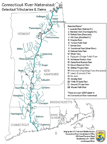
{{Image|Connecticut River Map.png|right|350px|The Connecticut River flows through the U.S. states of New Hampshire, Vermont, Massachussetts and Connecticut.}}
The '''Connecticut River''' is the longest river in the [[New England]], flowing roughly southward from just south of [[Quebec]] for 406 miles through NH, VT, MA and CT until it reaches the [[Long Island Sound]].  Its watershed includes parts of five U.S. states and one Canadian province, via 148 tributaries, 38 of which are major rivers.<ref name="ctriver.org" />  The river valley is home to highly productive farmland and passes through the middle of the metropolitan region of approximately two million people surrounding [[Springfield, Massachusetts]], and [[Hartford, Connecticut]].


The '''Connecticut River''' is the longest river in the [[New England]] region of the [[United States of America|U.S.]], flowing roughly southward for 406 miles through four states. It rises 300 yards (270 m) south of the U.S. border with [[Quebec]], [[Canada]], and discharges at [[Long Island Sound]].<ref>{{cite web| url=https://www.bbc.co.uk/essex/features/essex_around_world/essex_connecticut.shtml| author=Linda Brughelli| title=Essex - Connecticut| work=BBC Local: Essex| date=October 28, 2014| access-date=August 9, 2016| archive-url=https://web.archive.org/web/20161020064052/http://www.bbc.co.uk/essex/features/essex_around_world/essex_connecticut.shtml| archive-date=October 20, 2016| url-status=live}}</ref> Its watershed encompasses 11,260 square miles, covering parts of five U.S. states and one Canadian province, via 148 tributaries, 38 of which are major rivers.<ref name="ctriver.org">{{cite web| url=http://www.ctriver.org/river-resources/about-our-rivers/watershed-facts/| title=Watershed Facts| publisher=Connecticut River Watershed Council| access-date=August 9, 2016| archive-url=https://web.archive.org/web/20160805023222/http://www.ctriver.org/river-resources/about-our-rivers/watershed-facts/| archive-date=August 5, 2016| url-status=live}}</ref> It produces 70% of Long Island Sound's fresh water,<ref name="ctriver.org"/> discharging at 18,400 cubic feet per second.<ref>{{Cite web|title=USGS Water-Year Summary for Site 01184000|url=https://waterdata.usgs.gov/nwis/annual?referred_module=sw&amp;site_no=01184000&amp;por_01184000_64671=1269463,00060,64671,1928,2020&amp;start_dt=1978&amp;end_dt=2016&amp;year_type=W&amp;format=html_table&amp;date_format=YYYY-MM-DD&amp;rdb_compression=file&amp;submitted_form=parameter_selection_list |access-date=January 12, 2021 |website=waterdata.usgs.gov |archive-date=February 27, 2021 |archive-url=https://web.archive.org/web/20210227164725/https://waterdata.usgs.gov/nwis/annual?referred_module=sw&site_no=01184000&por_01184000_64671=1269463,00060,64671,1928,2020&start_dt=1978&end_dt=2016&year_type=W&format=html_table&date_format=YYYY-MM-DD&rdb_compression=file&submitted_form=parameter_selection_list |url-status=live}}</ref>
The river and its tributaries are highly dammed, with as many as 65 major dams that are a primary source of hydroelectric power in the region.


The Connecticut River Valley is home to some of the northeastern United States' most productive farmland, as well as the [[Hartford–Springfield|Hartford–Springfield Knowledge Corridor]], a metropolitan region of approximately two million people surrounding [[Springfield, Massachusetts]], and [[Hartford, Connecticut]].<ref name="connecticutriver.us">{{cite web| url=http://connecticutriver.us/site/content/about-river| title=About the River| website=Connecticutriver.us| access-date=August 9, 2016| archive-url=https://web.archive.org/web/20160815051454/http://connecticutriver.us/site/content/about-river| archive-date=August 15, 2016| url-status=live}}</ref>
==Notes==
<references>
 
<ref name="ctriver.org">
{{cite web| url=http://www.ctriver.org/river-resources/about-our-rivers/watershed-facts/| title=Watershed Facts| publisher=Connecticut River Watershed Council| access-date=August 9, 2016| archive-url=https://web.archive.org/web/20160805023222/http://www.ctriver.org/river-resources/about-our-rivers/watershed-facts/| archive-date=August 5, 2016| url-status=live}}
</ref>
 
</references>

Latest revision as of 09:18, 7 August 2023

This article is a stub and thus not approved.
Main Article
Discussion
Related Articles  [?]
Bibliography  [?]
External Links  [?]
Citable Version  [?]
 
This editable Main Article is under development and subject to a disclaimer.
The Connecticut River flows through the U.S. states of New Hampshire, Vermont, Massachussetts and Connecticut.

The Connecticut River is the longest river in the New England, flowing roughly southward from just south of Quebec for 406 miles through NH, VT, MA and CT until it reaches the Long Island Sound. Its watershed includes parts of five U.S. states and one Canadian province, via 148 tributaries, 38 of which are major rivers.[1] The river valley is home to highly productive farmland and passes through the middle of the metropolitan region of approximately two million people surrounding Springfield, Massachusetts, and Hartford, Connecticut.

The river and its tributaries are highly dammed, with as many as 65 major dams that are a primary source of hydroelectric power in the region.

Notes

  1. Watershed Facts. Connecticut River Watershed Council.