Tombolo: Difference between revisions
Jump to navigation
Jump to search

Pat Palmer (talk | contribs) (adding another image) |
Pat Palmer (talk | contribs) mNo edit summary |
||
| Line 1: | Line 1: | ||
{{subpages}} | {{subpages}} | ||
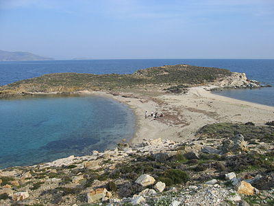
{{Image|Tombolo Paximadhi Eboea.jpg|right|400px|An example of a tombolo | {{Image|Tombolo Paximadhi Eboea.jpg|right|400px|An example of a tombolo seen from the air. This one is on cape Paximadhi in [[Greece]].}} | ||
{{Image|Accreting coast Image6.svg|right|400px|Coastal and oceanic landforms. Cuspate foreland, tombolo, spit, bay, lagoon, barrier island.}} | {{Image|Accreting coast Image6.svg|right|400px|Coastal and oceanic landforms. Cuspate foreland, tombolo, spit, bay, lagoon, barrier island.}} | ||
'''Tombolo''' is the geographic term for an [[isthmus]] formed when currents carrying sand are slowed by an island, depositing a sandbar that transforms the island into a [[peninsula]].<ref name=Mahiques/> [[Presqu'ile (Ontario)]] is an example of a tombolo. | '''Tombolo''' is the geographic term for an [[isthmus]] formed when currents carrying sand are slowed by an island, depositing a sandbar that transforms the island into a [[peninsula]].<ref name=Mahiques/> [[Presqu'ile (Ontario)]] is an example of a tombolo. | ||
Revision as of 08:15, 11 March 2024

An example of a tombolo seen from the air. This one is on cape Paximadhi in Greece.

Tombolo is the geographic term for an isthmus formed when currents carrying sand are slowed by an island, depositing a sandbar that transforms the island into a peninsula.[1] Presqu'ile (Ontario) is an example of a tombolo.
References
- ↑ Michel Michaelovitch De Mahiques (2016). “Tombolo”, Encyclopedia of Estuaries, 713–714. DOI:10.1007/978-94-017-8801-4_349. ISBN 978-94-017-8800-7.