South Korea: Difference between revisions
imported>Chunbum Park |
imported>Chunbum Park |
||
| Line 13: | Line 13: | ||
The other group of volcanic islands in South Korea are [[Ulleungdo]] and [[Dokdo|Dokdo (Liancourt Rocks)]] that formed in the [[Sea of Japan|East Sea]] 2.5 and 4.6 million years ago, respectively.<ref name="koreanetulleungdok">[http://www.korea.net/news/issues/issueDetailView.asp?board_no=12364 Travel Information], Korea.net, May 22, 2006.</ref> | The other group of volcanic islands in South Korea are [[Ulleungdo]] and [[Dokdo|Dokdo (Liancourt Rocks)]] that formed in the [[Sea of Japan|East Sea]] 2.5 and 4.6 million years ago, respectively.<ref name="koreanetulleungdok">[http://www.korea.net/news/issues/issueDetailView.asp?board_no=12364 Travel Information], Korea.net, May 22, 2006.</ref> | ||
The three major rivers in South Korea are the [[Han River|Han]], [[Geum River|Geum]], and [[Nakdong River|Nakdong]], all of which originate from the Taebaek range. The Han River is where the capital is situated, and it is the second largest in South Korea. The Han and Geum rivers drain into the [[Yellow Sea]], and the Nakdong River, the longest river in South Korea, empties south into the [[Korea Strait]]. Similarly, most of the other fluvial channels in the country run westward or southward. | The three major rivers in South Korea are the [[Han River|Han]], [[Geum River|Geum]], and [[Nakdong River|Nakdong]], all of which originate from the Taebaek range. The Han River is where the capital is situated, and it is the second largest in South Korea. The Han and Geum rivers drain into the [[Yellow Sea]], and the Nakdong River, the longest river in South Korea, empties south into the [[Korea Strait]]. Similarly, most of the other fluvial channels in the country also run westward into or southward into the 2 seas. | ||
== Politics == | == Politics == | ||
Revision as of 19:03, 13 November 2008
South Korea, officially the Republic of Korea or ROK (Korean: Namhan; Daehan Min-guk[1]),[2] is a constitutional republic comprising the southern part of Korea, which protrudes southward from the Northeastern Asian mainland and lies between the Yellow Sea and the Sea of Japan (East Sea). Its East Asian neighbors include China, Taiwan, and Japan, which share strong historical and cultural ties with Korea. When South Korea was established in 1948 after the end of Japanese colonial rule, the country was one of the poorest in the world, and its economic prospect worsened with destruction of the nation's infrastructure during the Korean War from 1950 to 1953. However, during the the early 1960s and the two decades that followed, South Korea transformed its largely agricultural economy into a modern industrial power and has currently the 13th largest GDP. Seoul is the capital of South Korea, and it is also the world's second largest city and a major technological and financial hub for the region. The country's current president is Yi Myungbak, who assumed office in February, 2008.
Geography
Physical constituency
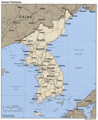
South Korea covers a total of 99,268 km2 (38,328 mi2) over 8 mainland provinces, the Jeju Island, and approximately 3,000 smaller islands appearing almost entirely on the western side of the peninsula. By comparison, the country is slightly larger than the U.S. state of Indiana and is about 4/5th the size of North Korea.
South Korea is largely mountainous, with only 30% of its terrain being the lowlands, concentrated mostly on the western and the southeastern parts of the country.[3] Along curve of the eastern coastline, the Taebaek Mountains, the northern end of which originates in North Korea, run in the north-south direction.[4] Four smaller mountain ranges branch off south-westward from the Tabaek Mountains, and, the largest among them, the Sobaek range, makes a long S-shape that divides the southern region. The highest points of these are the Mount Jiri on the Sobaek Mountains, reaching a height of 1,915 m (6,283 ft), and Mount Sorak on the Taebaek range, peaking at 1,708 m (5,604 ft), but none are as high as Mount Halla, which is an extinct volcano with a height of 1,950 m (6,398 ft). It is located on Jejudo, which is the largest island in the country.
The other group of volcanic islands in South Korea are Ulleungdo and Dokdo (Liancourt Rocks) that formed in the East Sea 2.5 and 4.6 million years ago, respectively.[5]
The three major rivers in South Korea are the Han, Geum, and Nakdong, all of which originate from the Taebaek range. The Han River is where the capital is situated, and it is the second largest in South Korea. The Han and Geum rivers drain into the Yellow Sea, and the Nakdong River, the longest river in South Korea, empties south into the Korea Strait. Similarly, most of the other fluvial channels in the country also run westward into or southward into the 2 seas.
Politics
Economy
Demography
History
Footnotes
- ↑ i.e. 'Great Nation of the People of Korea'
- ↑ According to the revised romanization of Korean.
- ↑ "South Korea," Microsoft Encarta Online Encyclopedia 2008.
- ↑ "Korea, South." Encyclopædia Britannica, date accessed: 2008-11-10.
- ↑ Travel Information, Korea.net, May 22, 2006.


