Idaho (U.S. state): Difference between revisions
Pat Palmer (talk | contribs) m (Text replacement - "Washington" to "Washington (U.S. state)") |
mNo edit summary |
||
| (10 intermediate revisions by 2 users not shown) | |||
| Line 1: | Line 1: | ||
{{subpages}} | {{subpages}} | ||
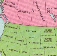
[[Image:NW USA.jpg|right|275px]] | [[Image:NW USA.jpg|right|275px]] | ||
'''Idaho''' is | '''Idaho''' is a landlocked state in the northwestern [[United States of America|U.S.]]. It was admitted as the 43rd state of the Union on July 3, 1890. It is mountainous state in the Pacific Northwest. | ||
Idaho has in the North a boundary with the Canadian province of [[British Columbia]] that follows the 49th parallel of latitude. Its southern border with [[Utah]] and [[Nevada]] follows the 42nd parallel. | Idaho has in the North a boundary with the Canadian province of [[British Columbia]] that follows the 49th parallel of latitude. Its southern border with [[Utah (U.S. state)|Utah]] and [[Nevada (U.S. state)|Nevada]] follows the 42nd parallel. | ||
The state's northeastern border is with [[Montana]] and the eastern border with [[Wyoming]] incorporates a small slice of [[Yellowstone National Park]]. On the west Idaho borders [[Oregon]] and [[Washington (U.S. state)]]. | The state's northeastern border is with [[Montana (U.S. state)|Montana]] and the eastern border with [[Wyoming (U.S. state)|Wyoming]] incorporates a small slice of [[Yellowstone National Park]]. On the west Idaho borders [[Oregon (U.S. state)|Oregon]] and [[Washington (U.S. state)]]. | ||
Idaho's surface is 83,564 square miles (216,432 square kilometers). According to the United States Census Bureau<ref>[http://www.census.gov/popest/states/tables/NST-EST2008-01.csv Census Bureau]</ref> in July 2008 the population for Idaho was estimated to be 1,523,816. | Idaho's surface is 83,564 square miles (216,432 square kilometers). According to the United States Census Bureau<ref>[http://www.census.gov/popest/states/tables/NST-EST2008-01.csv Census Bureau]</ref> in July 2008 the population for Idaho was estimated to be 1,523,816. | ||
[[Boise]] is the capital of Idaho. | [[Boise, Idaho|Boise]] is the capital of Idaho. | ||
{{Image|Idaho.jpg|right|225px|USGS shaded relief map of Idaho}} | {{Image|Idaho.jpg|right|225px|USGS shaded relief map of Idaho}} | ||
==See also== | |||
[[United States of America/Catalogs/States and Territories|U.S. States and Territories]] | |||
==References== | ==References== | ||
<references /> | <references />[[Category:Suggestion Bot Tag]] | ||
Latest revision as of 06:00, 31 August 2024
Idaho is a landlocked state in the northwestern U.S.. It was admitted as the 43rd state of the Union on July 3, 1890. It is mountainous state in the Pacific Northwest.
Idaho has in the North a boundary with the Canadian province of British Columbia that follows the 49th parallel of latitude. Its southern border with Utah and Nevada follows the 42nd parallel. The state's northeastern border is with Montana and the eastern border with Wyoming incorporates a small slice of Yellowstone National Park. On the west Idaho borders Oregon and Washington (U.S. state). Idaho's surface is 83,564 square miles (216,432 square kilometers). According to the United States Census Bureau[1] in July 2008 the population for Idaho was estimated to be 1,523,816.
Boise is the capital of Idaho.

