Garrison Creek (Ontario)
Garrison Creek was a short creek about 6 kilometres long, that flowed southeast into the west side of Toronto Harbour.[1][2] It has been largely covered over and filled in, but geographical traces of the creek can still be found. The natural ampitheatre known as Christie Pits is one such remnant, the south end of Trinity Bellwoods Park is another. The name "Garrison Creek" was used because Fort York was built near the creek mouth.
Volunteers lead popular tours of the course of the old watershed.

In 2013 particular strong rainstorms caused the storm sewers that replaced Garrison Creek to flood, at Christie Pits, Trinity Bellwoods Park, and a railway underpass at King Street and Atlantic Avenue.[3] Both Christie Pits and Trinity Bellwoods Park are over the original Garrison Creek Ravine, while the King and Atlantic intersection is over the course of Asylum Stream, a tributary.
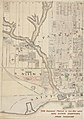
Map
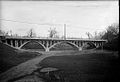
Ravine in 1915
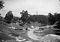
Ravine in 1914


References
- ↑ Garrison Creek, Lost river walks. mirror
- ↑ Kevin Plummer. Buried Under Bellwoods, Torontoist. Retrieved on 2011-06-26. mirror
- ↑ Todd Harrison. Toronto Flood 2013: The revenge of Garrison Creek, Spacings magazine, 2013-07-09. Retrieved on 2014-04-03. “Buried since the early 1900s, Garrison Creek now flows through a series of storm sewers from north of Davenport Road down to Lake Ontario. Christie Pits and Trinity Bellwoods are along the route of the creek proper, while the corner of King and Atlantic (pictured above) is near an adjoining buried waterway called Asylum Stream.” mirror