North Dakota (U.S. state)
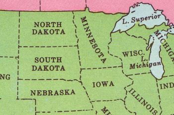
North Dakota is one of the states constituting the United States of America; it entered the Union as 39th state on November 2, 1889. Its area is 70,702 square miles (183,119 square kilometers) and its estimated population in 2008 was 641,481. The state is bordered by Canada on the north, Minnesota on the east, South Dakota on the south, and Montana on the west. The largest city is Fargo (population in 2008: 99,200), and Bismarck is the capital.
The University of North Dakota in Grand Forks was founded in 1883 and North Dakota State University, founded in 1890, is in Fargo.
Land
Physiography (land forms)
Rivers and drainage, lakes
Climate
Soil
Flora
Tourism
The Theodore Roosevelt National Park is one of the largest tourist destinations in North Dakota. It is located in the southwest part of the state, near Medora, North Dakota, a tourist town that still looks like it did in the Old Wild West period. The Chateua de Mores, a 26-room mansion southwest of Medora, is another popular attraction.
Military
There are several important U.S. military facilities in the state, especially Minot Air Force Base, one of the two domestic bases for B-52 bombers under the Eighth Air Force. For readiness, its bombers are under the Air Combat Command, but are assigned either to regional Unified Combatant Commands or the United States Strategic Command (USSTRATCOM) for combat operations. Minot also hosts the 91st Space Wing of LGM-30 Minuteman intercontinental ballistic missiles.
Grand Forks Air Force Base had long been an air defense facility, but has been realigned as a facility for air refueling tankers under the Air Mobility Command. A major space and missile surveillance radar, the Perimeter Acquisition Radar and Attack Characterization System (PARCS), operated by the 10th Space Warning Squadron (10th SWS) is located at the Cavalier Air Force Station, which receives housekeeping support from Grand Forks. Organizationally, the 10th SWS reports to the 21st Space Wing of the Air Force Space Command, with reporting to the North American Aerospace Defense Command (NORAD) and USSTRATCOM.
The 119th Air National Guard Wing shares the Fargo civilian airport, also known as Hector International Airport. Formerly assigned an air defense mission with F-16 Fighting Falcon aircraft, it has been realigned to provide various support functions to worldwide expeditionary operations. As a National Guard unit, it has also been active in domestic emergencies, such as recent floods in North Dakota.

