File:Putnam Map.png: Difference between revisions
imported>Milton Beychok ({{Image_Details|permission |description = Map of Social Capital in the United States |author = Later |copyright = Later |source = Later |date-created = Later |pub-country = United States |notes = |versions = }}) |
imported>Milton Beychok (→Summary: Expanded the Summary) |
||
| Line 2: | Line 2: | ||
{{Image_Details|permission | {{Image_Details|permission | ||
|description = Map of Social Capital in the United States | |description = Map of Social Capital in the United States | ||
|author = | |author = See notes below | ||
|copyright = | |copyright = See notes below | ||
|source = | |source = See notes below | ||
|date-created = | |date-created = See notes below | ||
|pub-country = United States | |pub-country = United States | ||
|notes = | |notes = The map is contained in Robert D. Putnam (2000), ''Bowling Alone: The Collapse and Revival of American Community''. New York: Simon and Schuster. p. 293. [[User:Roger Lohmann|Roger Lohmann]] obtained permission to use the map in Citizendium and asked me to re-color it, which I did. 15:54, 31 May 2010 (UTC) | ||
|versions = | |versions = | ||
}} | }} | ||
== Licensing/Copyright status == | == Licensing/Copyright status == | ||
{{Bypermission-reuse}} | {{Bypermission-reuse}} | ||
Revision as of 10:54, 31 May 2010
Summary
| Title / Description
|
Map of Social Capital in the United States |
|---|---|
| Author(s)
|
See notes below |
| Copyright holder
|
See notes below See below for license/re-use information. |
| Source
|
See notes below |
| Date created
|
See notes below |
| Country of first publication
|
United States |
| Notes
|
The map is contained in Robert D. Putnam (2000), Bowling Alone: The Collapse and Revival of American Community. New York: Simon and Schuster. p. 293. Roger Lohmann obtained permission to use the map in Citizendium and asked me to re-color it, which I did. 15:54, 31 May 2010 (UTC) |
| Other versions
|
If there are other versions of this media on CZ, please list them here. |
| Using this image on CZ
|
Copy the code below to add this image to a Citizendium article, changing the size, alignment, and caption as necessary.
|
Please send email to manager A T citizendium.org .
Licensing/Copyright status
This media, Putnam Map.png, is copyrighted, all rights reserved.
The copyright holder has granted permission for use of this image on the Citizendium.
The terms of the permission allow third party use but may restrict usages.
Please provide the written permission to use this image on the Permission page.
Notice of CC-by-sa incompatibility
Text on the Citizendium is licensed under the Creative Commons Attribution ShareAlike licence.
This media may not be used under those or closely similar terms without separate permission of the copyright holder, or the user's own fair use determination.
File history
Click on a date/time to view the file as it appeared at that time.
| Date/Time | Thumbnail | Dimensions | User | Comment | |
|---|---|---|---|---|---|
| current | 19:54, 11 March 2022 | 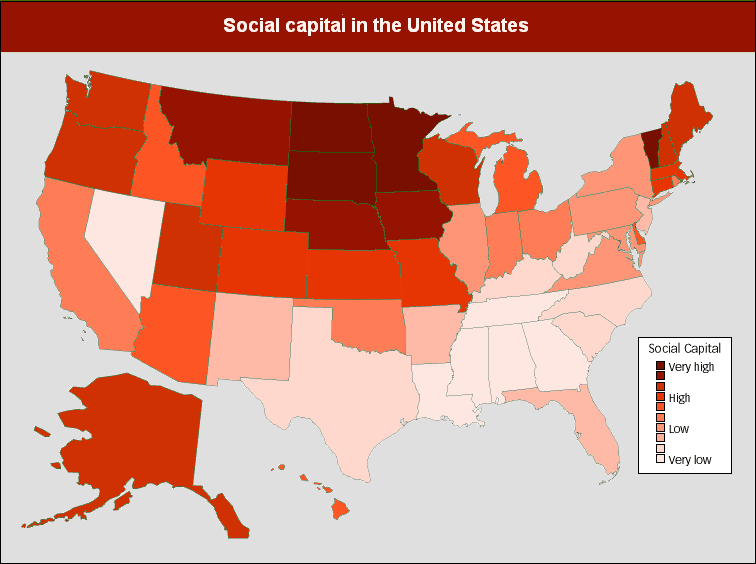 | 756 × 564 (45 KB) | Maintenance script (talk | contribs) | == Summary == Importing file |
You cannot overwrite this file.
File usage
The following 2 pages use this file: