File:Ancient Greece Including Ionia.JPG: Difference between revisions
Jump to navigation
Jump to search
imported>Anthony.Sebastian ({{Image notes |Description= Map of Ancient Greece Including Ionia |Author= Ed Snible, http://www.snible.org/greek/ |Date= April 2008 |Source= http://www.snible.org/greek/map4g.jpg |Country first published in= Unknown |Copyright holder= public domain: "Public domain high resolution maps of ancient Greece and the ancient Greek world: Asia Minor. Including Pontus, Cappadocia, Cilicia, Pisidia, Lycia, Caria, Lydia, Mysia, Bithynia, Paphlagonia, Phrygia, and Crete. Central Europe. Including Panno...) |
imported>Caesar Schinas m (Bot: Replace Template:Image_notes_* with Template:Image_Details) |
||
| Line 1: | Line 1: | ||
== Summary == | == Summary == | ||
{{ | {{Image_Details | ||
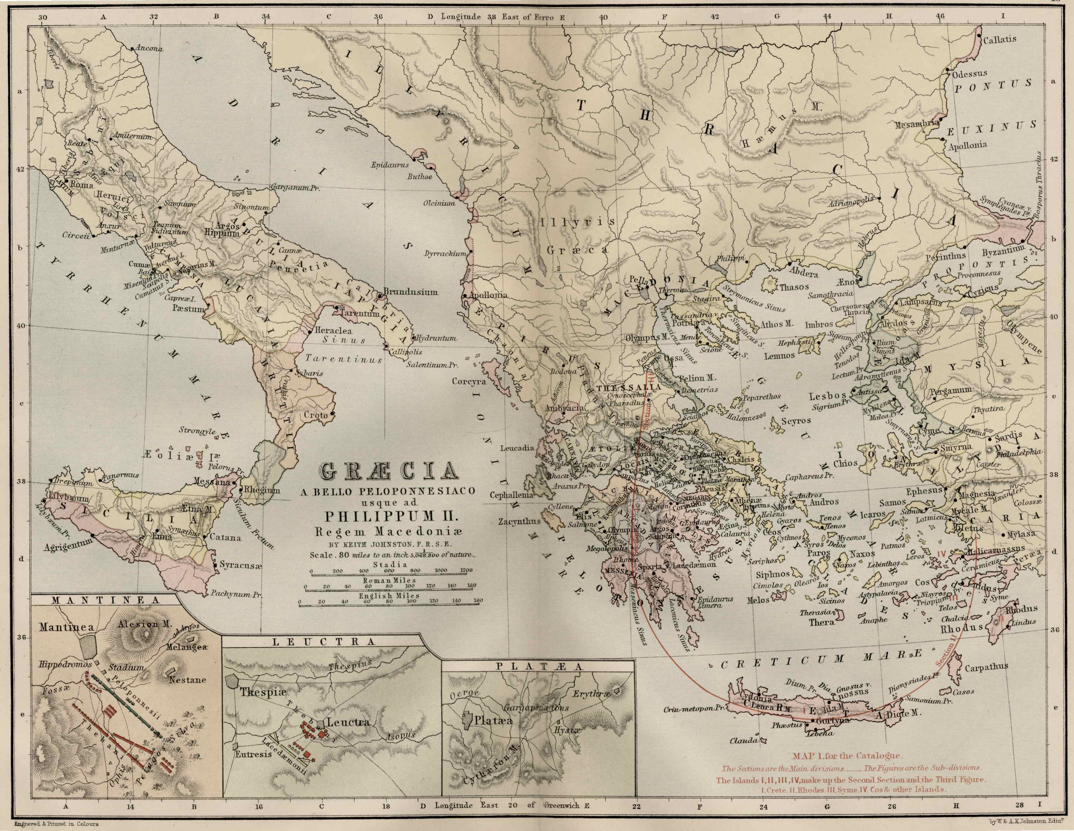
| | |description = Map of Ancient Greece Including Ionia | ||
| | |author = Ed Snible, http://www.snible.org/greek/ | ||
| | |copyright = public domain: "Public domain high resolution maps of ancient Greece and the ancient Greek world: Asia Minor. Including Pontus, Cappadocia, Cilicia, Pisidia, Lycia, Caria, Lydia, Mysia, Bithynia, Paphlagonia, Phrygia, and Crete. Central Europe. Including Pannonia, Dacia, Thrace, Macedon, Illyricum, Moesia. Italy and Sicily. Greece. Attica, Euboia, Locris, Boeotia, Aitolia, Corinthia, Peloponnesos. | ||
|source = http://www.snible.org/greek/map4g.jpg | |||
|date-created = April 2008 | |||
|pub-country = Unknown | |||
| | |notes = | ||
| | |versions = | ||
}} | |||
== Licensing/Copyright status == | == Licensing/Copyright status == | ||
{{Test-template}} | {{Test-template}} | ||
Revision as of 04:32, 22 June 2009
Summary
| Title / Description
|
Map of Ancient Greece Including Ionia |
|---|---|
| Author(s)
|
Ed Snible, http://www.snible.org/greek/ |
| Copyright holder
|
public domain: "Public domain high resolution maps of ancient Greece and the ancient Greek world: Asia Minor. Including Pontus, Cappadocia, Cilicia, Pisidia, Lycia, Caria, Lydia, Mysia, Bithynia, Paphlagonia, Phrygia, and Crete. Central Europe. Including Pannonia, Dacia, Thrace, Macedon, Illyricum, Moesia. Italy and Sicily. Greece. Attica, Euboia, Locris, Boeotia, Aitolia, Corinthia, Peloponnesos. See below for license/re-use information. |
| Source
|
http://www.snible.org/greek/map4g.jpg |
| Date created
|
April 2008 |
| Country of first publication
|
Unknown |
| Notes
|
You can edit this page and add notes here which may be useful to people who wish to re-use this media. |
| Other versions
|
If there are other versions of this media on CZ, please list them here. |
| Using this image on CZ
|
Copy the code below to add this image to a Citizendium article, changing the size, alignment, and caption as necessary.
|
Image issue? Contact us via the email below.
Please send email to manager A T citizendium.org .
Licensing/Copyright status
File history
Click on a date/time to view the file as it appeared at that time.
| Date/Time | Thumbnail | Dimensions | User | Comment | |
|---|---|---|---|---|---|
| current | 19:56, 11 March 2022 |  | 3,680 × 2,848 (923 KB) | Maintenance script (talk | contribs) | == Summary == Importing file |
You cannot overwrite this file.
File usage
The following page uses this file: