File:A Jesuit Map With Sea of Japan.png
Jump to navigation
Jump to search
No higher resolution available.
A_Jesuit_Map_With_Sea_of_Japan.png (758 × 499 pixels, file size: 448 KB, MIME type: image/png)
| Title / Description
|
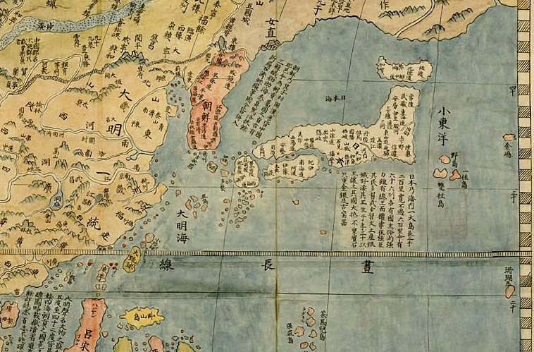
Title: "Kunyu Wanguo Quantu." The first map in the world to describe the sea between Korea and Japan as the Sea of Japan. |
|---|---|
| Author(s)
|
Matteo Ricci |
| Copyright holder
|
N/A See below for license/re-use information. |
| Source
|
http://www2.library.tohoku.ac.jp/kano/ezu/kon/kon_frm_32.html |
| Date created
|
1602 |
| Country of first publication
|
China |
| Notes
|
You can edit this page and add notes here which may be useful to people who wish to re-use this media. |
| Other versions
|
If there are other versions of this media on CZ, please list them here. |
| Using this image on CZ
|
Copy the code below to add this image to a Citizendium article, changing the size, alignment, and caption as necessary.
|
Image issue? Contact us via the email below.
Please send email to manager A T citizendium.org .
File history
Click on a date/time to view the file as it appeared at that time.
| Date/Time | Thumbnail | Dimensions | User | Comment | |
|---|---|---|---|---|---|
| current | 19:52, 11 March 2022 | | 758 × 499 (448 KB) | Maintenance script (talk | contribs) | == Summary == Importing file |
You cannot overwrite this file.
File usage
The following 2 pages use this file: