Boothia Peninsula: Difference between revisions
Jump to navigation
Jump to search

imported>George Swan (fix refs) |
imported>Caesar Schinas m (Bot: Update image code) |
||
| Line 1: | Line 1: | ||
{{subpages}} | {{subpages}} | ||
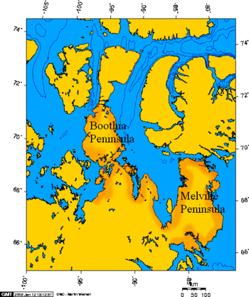
{{Image|Boothia and melville peninsula 1.PNG|right|350px|Add image caption here.}} | |||
The '''Boothia Peninsula''' is a large peninsula that on the Northern Coast of [[Nunavut]], [[Canada]]. Its Northern tip is the Northernmost location on continental [[North America]].<ref name=Cbc20061027> | The '''Boothia Peninsula''' is a large peninsula that on the Northern Coast of [[Nunavut]], [[Canada]]. Its Northern tip is the Northernmost location on continental [[North America]].<ref name=Cbc20061027> | ||
Latest revision as of 06:25, 8 June 2009
The Boothia Peninsula is a large peninsula that on the Northern Coast of Nunavut, Canada. Its Northern tip is the Northernmost location on continental North America.[1]
Failed attempts to traverse the Northwest Passage, tried to pass through the narrow Bellot Strait between the Boothia Peninsula and Somerset Island.
Tides through the strait can flow at 8 knots. Ships can be pinned within dangerous ice packs, and packs of even larger iceberg fragments.
References
- ↑ Northwest Passage: The National visits Canada's North, CBC News, 2006-10-27. Retrieved on 2008-08-14. mirror
