User:Graham Harris/Seychelles
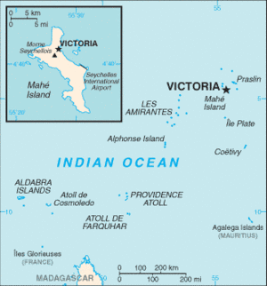
The Republic of Seychelles is an island nation in the Indian Ocean. The archipelago lies northeast of Madagascar and 1,000 miles east of Kenya. Its population is 80,000, the smallest of any sovereign African nation, with most of its citizens of French and East African ancestry.
History
The Seychelles were first mapped by Portuguese explorers in 1505 but known to local seafaring people earlier. In 1609 the British East India Company landed on the islands and found them uninhabited.
Lazare Picault explored the islands in 1742, and the Séchelles were officially annexed by France in 1756. The French created a supply outpost that grew crops and harvested natural resources. (expand - decimation of giant tortoises and hardwood forests).
After a lengthy struggle with Britain, possession of the islands was ceded by France in 1814.
- Description of French colony during this time, when was it set up, what did it do.
- Dependency on Mauritius until 1904, both Mauritius and Seychelles passed from French to British
- History of ethnic groups brought to the islands as slaves and laborers
- French and East African ancestry
- Indian, Chinese, and Arab
- End of slavery switched economy from plantations to other
Initially uninhabited when discovered by western explorers. On Portuguese maps by 1505.
- 1505 on Portuguese maps
- 1609 landed on by the British East India Company
- 1742 explored by Lazare Picault
- 1756 Séchelles annexed by France, named after French minister of finance under King Louis XV, Marie-Jean Hérault de Séchelles
- 1810 surrender to British by France
- 1814 Treaty of Paris, ceded to Great Britain, now Seychelles
- ~1830 abolition of slavery
- 1888 beginnings of self rule, executive and administrative councils set up
- 1903 a British crown colony
- 1948 a Legislative Council was created
- 1970 new constitution
- 1975 self-government, James R. Mancham first president, France-Albert René prime minister
- 1976 independence within the Commonwealth
- 1977 France-Albert René became president in a coup d'état
- 1979 became a one-party socialist state, Seychelles People's Progressive Front (FPPS)
- 1993 new constitution and free elections
- 2004 France-Albert René, in power since 1977, steps down. James Michel steps up [2]
Geography
Located at 5°S 50°E, the Seychelles are a group of about 120 tropical islands making up 444 square kilometers of land. Mahé is the main island and location of the capitol city Vicoria. Within about 90 KM of Mahé are some 40 other islands with similar granitic and hilly geography. Average rainfall on Mahé is 2,880 mm at sea level and 3,550 on its slopes. A second group of islands make up the rest of the archipelago. These are flat and corillian with little fresh water and spread over 1,200 Km from northeast to southwest.[3]
Climate: Tropical-oceanic cliamate with little yearly temperature variation.
Flora and Fauna
Tropical and lush.
People
Native toung Kreol (Seychellois Creole), but English is the official language (ref CIA).
Government
Current president James Michel.
Economy
Exports: Fish, cinnamon bark, copra, petroleum products (re-exports)(BBC)
Culture
Military
Transportation
References
- ↑ Helen Chapin Metz (Editor, 1994) A Country Study: Seychelles, U.S. Library of Congress, Federal Research Division
- ↑ The World Factbook, Seychelles, CIA (2007)
- ↑ Thomas R. Yager (2003), Teg Mineral Idustries of Burundi, Comoros, Malawi, Mauritius, Reunion, Rwanda, and Seychelles, USGS
