Search results
Jump to navigation
Jump to search
Page title matches
- ...er-state-with-current-identities orig.jpg | thumb | left | 1810 map of the Falls of the Ohio]] ...wing the artificial canal to the south, and the (submerge) location of the Falls of the Ohio.jpg | thumb | modern aerial photo of the area of the Falls. Note the south645 bytes (99 words) - 08:29, 4 March 2022
- 12 bytes (1 word) - 08:30, 4 March 2022
- | pagename = Falls of the Ohio | abc = Falls of the Ohio825 bytes (70 words) - 08:30, 4 March 2022
- 116 bytes (13 words) - 08:32, 4 March 2022
Page text matches
- ...er-state-with-current-identities orig.jpg | thumb | left | 1810 map of the Falls of the Ohio]] ...wing the artificial canal to the south, and the (submerge) location of the Falls of the Ohio.jpg | thumb | modern aerial photo of the area of the Falls. Note the south645 bytes (99 words) - 08:29, 4 March 2022
- #REDIRECT [[Falls of the Ohio]]31 bytes (5 words) - 08:29, 4 March 2022
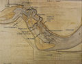
File:1810-falls-area-low-water-state-with-current-identities orig.jpg |description = The [[Falls of the Ohio]], at [[Louisville, Kentucky]], were the only navigational obstacle on the(1,019 × 800 (200 KB)) - 20:55, 18 April 2022- | pagename = Falls of the Ohio | abc = Falls of the Ohio825 bytes (70 words) - 08:30, 4 March 2022
- The [[Falls of the Ohio]], at present day [[Louisville, Kentucky]], was the only navigational obsta2 KB (315 words) - 19:50, 6 March 2024
- # [[Falls of the Ohio]]13 KB (1,299 words) - 08:38, 31 May 2024
