File:1562 Americæ Gutiérrez map.JPG
Jump to navigation
Jump to search
1562_Americæ_Gutiérrez_map.JPG (547 × 600 pixels, file size: 170 KB, MIME type: image/jpeg)
Summary
| Title / Description
|
A 1562 map of the Americas. |
|---|---|
| Author(s)
|
Diego Gutiérrez and Hieronymus Cock |
| Source
|
http://en.wikipedia.org/wiki/File:1562_Americ%C3%A6_Guti%C3%A9rrez.JPG |
| Date created
|
1562 |
| Country of first publication
|
Spain |
| Notes
|
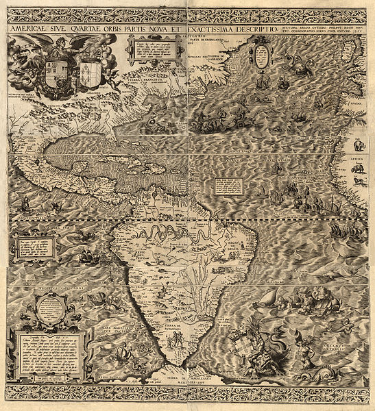
The 1562 map of the Americas titled “’’Americae sive quartae orbis partis nova et exactissima descriptio’’” (Latin: "The Americas, or A New and Precise Description of the Fourth Part of the World") by Diego Gutiérrez and engraver Hieronymus Cock. It was the earliest scale wall map of the New World and the first to apply the name California. The Tropics of Cancer, Capricorn and the equator are used as reference latitudes. The Spanish and French coats of arms appear together, embraced by Victory, symbolizing the 1559 marriage between Phillip II of Spain and Elisabeth of Valois. In 1554, Diego Gutiérrez was appointed principal cosmographer to the king of Spain in the Casa de la Contratación. The crown commissioned the Casa to produce a large-scale map of the western hemisphere, often called the "fourth part of the world." The purpose of the map was to assert Spain’s claims to new world territories against the rival claims of Portugal and France. Spain claimed all lands south of the Tropic of Cancer, which is shown prominently. The map was engraved by the famous Antwerp engraver Hieronymus Cock, who added numerous artistic flourishes, including the coats of arms of the three rival powers, a snake-like Amazon River that winds across the northern part of South America, mermaids and mythical monsters at sea, and an elephant, rhinoceros, and lion on the western coast of Africa. The name "California" is inscribed near Baja California, just above the Tropic of Cancer, the first time it appears on any printed map. Only two copies of the map are known to exist: this one from the collections of the Library of Congress, and another in the British Library. |
| Other versions
|
If there are other versions of this media on CZ, please list them here. |
| Using this image on CZ
|
Copy the code below to add this image to a Citizendium article, changing the size, alignment, and caption as necessary.
|
Image issue? Contact us via the email below.
Please send email to manager A T citizendium.org .
Licensing
This media, 1562 Americæ Gutiérrez map.JPG, is in the public domain
Any copyright on this work has expired.
This applies to in the European Union, the United States, Canada, and other countries with a copyright term of life of the author plus 70 years.
You may freely copy, distribute, display and perform this work, as well as make derivative and commercial works.
File history
Click on a date/time to view the file as it appeared at that time.
| Date/Time | Thumbnail | Dimensions | User | Comment | |
|---|---|---|---|---|---|
| current | 19:57, 11 March 2022 |  | 547 × 600 (170 KB) | Maintenance script (talk | contribs) | == Summary == Importing file |
You cannot overwrite this file.
File usage
The following page uses this file:
