File:A German Map With Minor Eastern Sea.jpg
A_German_Map_With_Minor_Eastern_Sea.jpg (430 × 369 pixels, file size: 89 KB, MIME type: image/jpeg)
| Title / Description
|
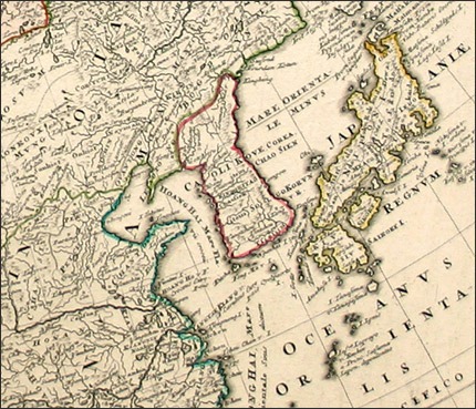
Title: "Imperii Russici et Tatariae universae tam majoris et Asiaticae, quam minoris et Europaeae tabula / ex recentissimis et probatissimis monumentis et relationibus concinata, et ad legitimas projectionum geographic. regulas plane exacta opera Ioh Matthiae Has;" it refers to the Sea of Japan as "Mare Orientale Minus," meaning the "Minor Eastern Sea." |
|---|---|
| Author(s)
|
Johann Matthias Hase |
| Copyright holder
|
N/A See below for license/re-use information. |
| Source
|
http://www.seaofkorea.org/bbs/map_5.php |
| Date created
|
1703 |
| Country of first publication
|
Germany |
| Notes
|
You can edit this page and add notes here which may be useful to people who wish to re-use this media. |
| Other versions
|
If there are other versions of this media on CZ, please list them here. |
| Using this image on CZ
|
Copy the code below to add this image to a Citizendium article, changing the size, alignment, and caption as necessary.
|
Please send email to manager A T citizendium.org .
Licensing/Copyright status
This media, A German Map With Minor Eastern Sea.jpg, is in the public domain
Any copyright on this work has expired.
This applies to in the European Union, the United States, Canada, and other countries with a copyright term of life of the author plus 70 years.
You may freely copy, distribute, display and perform this work, as well as make derivative and commercial works.
File history
Click on a date/time to view the file as it appeared at that time.
| Date/Time | Thumbnail | Dimensions | User | Comment | |
|---|---|---|---|---|---|
| current | 19:57, 11 March 2022 | | 430 × 369 (89 KB) | Maintenance script (talk | contribs) | == Summary == Importing file |
You cannot overwrite this file.
File usage
The following page uses this file: