File:Internet map 1024.jpg: Difference between revisions

From Citizendium
Jump to navigation Jump to search
imported>Caesar Schinas
m (Replace Template:Information with Template:Image_Details)
(== Summary == Importing file)
Tag: Server-side upload
 
Line 1: Line 1:
 
== Summary ==
{{Image_Details
Importing file
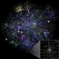
| description  = This image is a visualization of a small number of internet routes (about 40,000).  Each line is drawn between two nodes, representing two [[IP address]]es.  The length of the lines are indicative of the delay between those two nodes.  This graph represents less than 30% of the [[Classful network|Class C]] networks reachable by the data collection program in early 2005.  Lines are color-coded according to their corresponding RFC 1918 allocation as follows:
 
* Dark blue: net, ca, us
* Green: com, org
* Red: mil, gov, edu
* Yellow: jp, cn, tw, au, de
* Magenta: uk, it, pl, fr
* Blue-green: br, kr, nl
* White: unknown
| author      = [[User:Matt Britt|Matt Britt]]
| copyright    = [[User:Matt Britt|Matt Britt]]
| source      = Self-made.  The data collection was performed by Barret Lyon and the original data sources can be found [http://www.opte.org/maps/ here].  I used a slightly different rendering technique than was used to generate the maps found there.
| date-created = November 2006
| pub-country  =
| notes        =
| versions    =
}}
 
== Licensing/Copyright status ==
{{CC|by|2.5}}

Latest revision as of 18:57, 11 March 2022

Summary

Importing file

File history

Click on a date/time to view the file as it appeared at that time.

Date/TimeThumbnailDimensionsUserComment
current18:57, 11 March 2022Thumbnail for version as of 18:57, 11 March 20221,280 × 1,280 (1.27 MB)Maintenance script (talk | contribs)== Summary == Importing file

The following 2 files are duplicates of this file (more details):

The following page uses this file:

Metadata