File:African Great Lakes and the Horn of Africa no grid.png: Difference between revisions
Jump to navigation
Jump to search
imported>George Swan (more details) |
imported>George Swan (uploaded a new version of "Image:African Great Lakes and the Horn of Africa no grid.png": another version) |
(No difference)
| |
Revision as of 20:16, 17 August 2008
Summary
| Title / Description
|
African Great Lakes and the Horn of Africa. Note smaller lakes showing the Great Rift Valley. |
|---|---|
| Author(s)
|
George Swan |
| Copyright holder
|
Please edit this page and add the name of the copyright holder, or note why this is not applicable. |
| Source
|
Please edit this page and add the source of this media, or note that it is unknown. |
| Date created
|
2008-08-17 |
| Country of first publication
|
Please edit this page and add the country of first publication, or note that it is unknown. |
| Notes
|
The data on political boundaries used to create this map predates the independence of Eritrea -- which severed Ethiopia from the Red Sea. |
| Other versions
|
If there are other versions of this media on CZ, please list them here. |
| Using this image on CZ
|
Copy the code below to add this image to a Citizendium article, changing the size, alignment, and caption as necessary.
|
Image issue? Contact us via the email below.
Please send email to manager A T citizendium.org .
Licensing/Copyright status
File history
Click on a date/time to view the file as it appeared at that time.
| Date/Time | Thumbnail | Dimensions | User | Comment | |
|---|---|---|---|---|---|
| current | 19:52, 11 March 2022 | 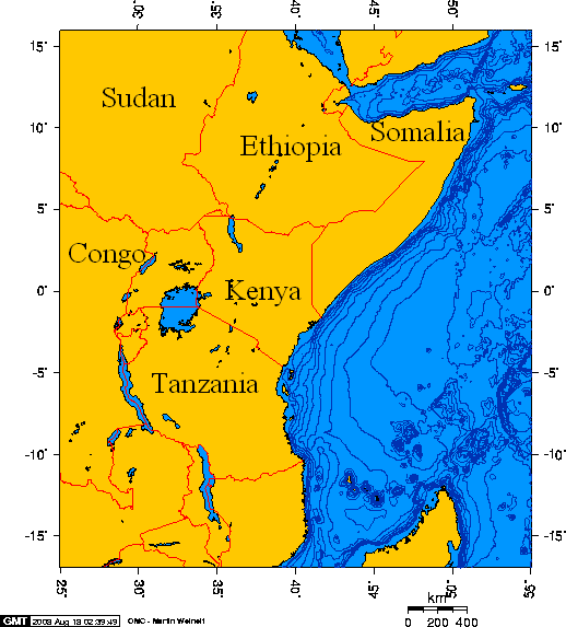 | 518 × 573 (33 KB) | Maintenance script (talk | contribs) | == Summary == Importing file |
You cannot overwrite this file.
File usage
The following page uses this file: