File:Algoma Navigator moored in the channel to Toronto's turning basin, 2014 01 01 -a (cropped).jpg

Original file (4,153 × 955 pixels, file size: 1.51 MB, MIME type: image/jpeg)
.jpg)
| Description |
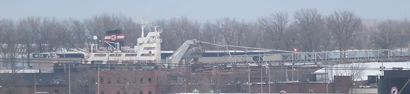
The Algoma Navigator moored in the channel to Toronto's turning basin. If you look closely you can see this vessel has a long boom. Self-unloading bulk-carriers can swing out their booms, to unload their cargoes. Their holds have V-shaped bottoms, with a conveyor belt below them. When doors at the bottom of a hold opens the cargo starts to drop to the lower conveyor belt. The cargo is carried to some kind of lifting devices, which places it on the upper conveyor belt on the boom. Older bulk carriers that are not self-unloading still carry cargo, but self-unloading vessels are now more common. Lake vessels, which are not exposed to salt water, can remain in service for decades longer than a "saltie", and a considerable number of older vessels have been retrofitted with self-unloading machinery. The Algoma Navigator was retrofitted in 1997. If you look closely you can see a logo on the smokestack of a bear -- the logo of Algoma Central, one of larger Canadian shipping lines. |
||
| Date | |||
| Source | Own work | ||
| Author | Geo Swan (talk) | ||
| Permission (Reusing this file) |
|
| Camera location | | View this and other nearby images on: OpenStreetMap |
|---|
.jpg¶ms=043.649078_N_-079.364208_E_globe:Earth_type:camera_source:exif_&language=en)
File history
Click on a date/time to view the file as it appeared at that time.
| Date/Time | Thumbnail | Dimensions | User | Comment | |
|---|---|---|---|---|---|
| current | 12:11, 11 January 2015 | 4,153 × 955 (1.51 MB) | imagescommonswiki>Geo Swan | {{Information | Description = The {{w|Algoma Navigator}} moored in the channel to Toronto's turning basin. If you look closely you can see this vessel has a long boom. Self-unloading bulk-carriers can swing out their booms, to unload their cargoes.... |
File usage
The following file is a duplicate of this file (more details):
.jpg)
The following page uses this file:
.jpg)